Find Your Perfect Business Degree
www.business-management-degree.net is an advertising-supported site. Featured or trusted partner programs and all school search, finder, or match results are for schools that compensate us. This compensation does not influence our school rankings, resource guides, or other editorially-independent information published on this site.
Google’s Roadmap to World Domination is a strategy developed by Google to become the most dominant player in all major markets. This effort is conducted through acquisitions, product development, innovative culture, data-driven decision-making, and partnerships.
By dominating various markets, Google hopes to increase its market share, customer base, R&D capabilities, and of course, its profits. The roadmap has been publicly outlined in Google’s financial statements and in the company’s annual reports.
Additionally, Google has stated its aim to become the “gatekeeper of the internet” as part of its mission. Google envisions its products and services playing a central role in our lives, and it is determined to ensure its growth by capitalizing on the opportunities provided by new and emerging markets.
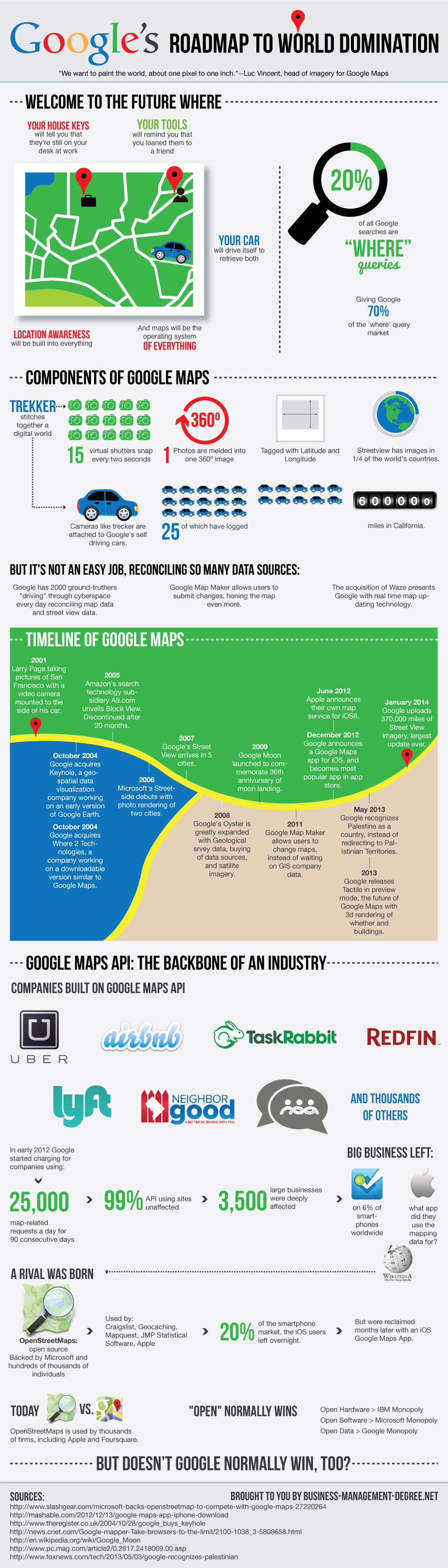
Google’s Roadmap to World Domination
“We want to paint the world, about one pixel to one inch.”–Luc Vincent, head of imagery for Google Maps
Welcome to the future:
Where your house keys will tell you they’re still on your desk at work
Your tools will remind you you loaned them to a friend
Your car will drive itself to retrieve both
(Google Promises a Self-Driving Car in 4 Years)[1]
(Tesla in three)[1]
Location awareness will be built into everything
And maps will be the operating system (of everything)
Currently: 20% of all Google searches are ‘where’ queries.
Giving Google 70% of the ‘where’ query market
Location-based services keep smartphones running.
Components of Google Maps(1)
(3)Trekker stitches together a digital world
15 virtual shutters snap every two seconds
Photos are melded into one 360 degree image
Tagged with Latitude and Longitude
—– 3 eight hour days with trekker down the Colorado river
Potentially yielded as many pictures as 20,000 yearly tourists visiting for 50 years.
Cameras like trecker are attached to Google’s self driving cars
25 of which have logged 600,000 miles in California.
Streetview has images in 1/4 of the world’s countries.
But it’s not an easy job, reconciling so many data sources:
Google has 2000 ground-truthers “driving” through cyberspace every day[1]:
Reconciling map data and street view data.
Google Map Maker allows users to submit changes, honing the map even more.
The acquisition of Waze presents Google with real time map updating technology.
Timeline of Google Maps(1)(2)(3)
2001– Larry Page taking pictures of San Francisco with a video camera mounted to the side of his car.
October 2004– Google acquires Where 2 Technologies, a company working on an early downloadable version similar to Google Maps.[4]
October 2004– Google acquires Keyhole, a geospatial data visualization company working on an early version of Google Earth.[3]
2004– Luc Vincent’s personal project (20% of Google employee time to devote to your own project) is Street View.
2005– Amazon’s search technology subsidiary A9.com unveils Block View, essentially Yellow Pages with storefront photos. Discontinued after 20 months.
2006–Microsoft’s Streetside debuts with photo rendering of two cities.
2007–Google’s Street View arrives in 5 cities.
2008– Google’s Oyster, or geographic database is greatly expanded with Geological srvey data, buying of data sources, and satilite imagery.
2009– Google Moon launched to commemorate 36th annivursary of moon landing.[5]
2011– Google Map Maker allows users to change maps, instead of waiting on GIS company data.
June 2012–Apple announces their own map service for iOS6.[2]
December 2012–Google announces a Google Maps app for iOS, immediately becomes most popular app in app store.[2]
May 2013–Google recognizes Palestine as a country, instead of redirecting to Palistinian Territories.[7]
2013– Google buys Waze, the social traffic app for close to $1 billion.
2013– Google releases Tactile in preview mode, the future of Google Maps with 3d rendering of whether and buildings.
January 2014–Google uploads 370,000 miles of Street View imagery, largest update ever.[6]
Google Maps API: the backbone of an industry(2)
Companies Built on Google Maps API
-AirBnB
-RedFin
-Uber
-RelayRides
-TaskRabbit
-Lyft
-NeighborGoods
And thousands of others.
In early 2012 Google started charging for companies using:
25,000 map related requests a day
For 90 consecutive days
99% API using sites unaffected
3,500 large business deeply affected:
Big Business Left:
Foursquare, on 6% of smartphones worldwide
Wikipedia
And Apple…
A rival was born
OpenStreetMaps: open source
Backed by:
Microsoft[2]
Hundreds of Thousands of individuals
Used by:
Craigslist, Geocaching, Mapquest, JMP Statistical Software, Apple
Overnight, 20% of the smartphone market, the iOS users left.
But were reclaimed several months later with an iOS Google Maps App.
Today: Open vs. Google
OpenStreetMaps is used by thousands of firms, including Apple and Foursquare.
(Started by mapping nerds several years ago, and enhanced by donations of satellite imagery from Apple.)
“Open” normally wins
Open Hardware > IBM Monopoly
Open Software > Microsoft Monopoly
???Open Data > Google Monopoly???
But doesn’t Google normally win, too?
Citations: